PRECISION AERIAL SERVICES, LLC
HOME Drone Services
CLIENTS & PROJECTS
CONTACT US
Construction Services
Structure Drone Services
Welcome
Aerial Lidar Services
PRECISION AERIAL SERVICES, LLC
HOME Drone Services
CLIENTS & PROJECTS
CONTACT US
Construction Services
Structure Drone Services
Welcome
Aerial Lidar Services
More
  • HOME Drone Services
  • CLIENTS & PROJECTS
  • CONTACT US
  • Construction Services
  • Structure Drone Services
  • Welcome
  • Aerial Lidar Services
  • HOME Drone Services
  • CLIENTS & PROJECTS
  • CONTACT US
  • Construction Services
  • Structure Drone Services
  • Welcome
  • Aerial Lidar Services

Budget Friendly Photogrammetry, Drone Mapping, & Lidar Services.

Budget Friendly Photogrammetry, Drone Mapping, & Lidar Services.Budget Friendly Photogrammetry, Drone Mapping, & Lidar Services.Budget Friendly Photogrammetry, Drone Mapping, & Lidar Services.
REQUEST A QUOTE

812-550-5063

Budget Friendly Photogrammetry, Drone Mapping, & Lidar Services.

Budget Friendly Photogrammetry, Drone Mapping, & Lidar Services.Budget Friendly Photogrammetry, Drone Mapping, & Lidar Services.Budget Friendly Photogrammetry, Drone Mapping, & Lidar Services.
REQUEST A QUOTE

812-550-5063

Welcome

 "Elevate your projects with our comprehensive Geospatial services tailored for Land Surveyors, Engineers, Utilities, Construction Firms, and Project Developers. We offer top-tier solutions including Aerial/Ground LIDAR, Survey Data, Bare Earth Topography Mapping, Volume calculations, Photogrammetry Mapping, 3D Reality

Discount Photogrammetry 3D Lidar Imaging construction progress photography video

When you trust boots on the ground to make crucial decisions, you need an eye in the sky to provide the information they need.

About Us

Precision Aerial Services, LLC, was founded in January of 2019 by John Carter and the great encouragement of his son Andrew Carter. The passion and challenge of operating a drone were met with enthusiasm by both father and son – this team went from flying kites, remote control model helicopters, and airplanes, to general aviation and now drones.


John has worked as a Sr. Field Engineer for several major companies, including the world's third-largest electronics designer and manufacturer. Combined with our knowledge of drone technology, Information Technology, and piloting skills, we have performed beta testing for several drone application designers and programmers. 


 "Elevate your projects with our comprehensive Geospatial services tailored for Land Surveyors, Engineers, Utilities, Construction Firms, and Project Developers. We offer top-tier solutions including Aerial/Ground LIDAR, Survey Data, Bare Earth Topography Mapping, Volume calculations, Photogrammetry Mapping, 3D Reality Capture, as-built vs. as-planned monitoring, construction progression monitoring, aerial imaging, 360-degree imaging, and UAV consulting. Trust us to bring your vision to life with precision and efficiency." 

Our Crew and Equipment

Our crew has over 35 years combined experience as Professional Photographers, and over 30 years general aviation pilot experience. Our fleet of state-of-the-art UAVs and unique experience in the field, enables our team to capture an array of  high-quality data and images safely. Our pilots hold FAA Part 107 certifications, are regularly DOT drug screened, insured, and continuously train to meet all new government drone regulations. Our UAV’s platforms can carry several sensors including, Photo/Video (RGB), NIR, NDVI, and Thermal. Geospatial Engineering Aerial LIDAR Topographic Mapping Land Surveying Discount Lidar Drone LiDAR drone photography Photogrammetry Drone Mapping

Our Services

Reasonably priced volumetrics and stockpile reporting Drone Photogrammetry 3D Lidar

We Offer A Variety Of Specialized Services For Our Clients

  • Lidar and Photogrammetry Aerial Survey Data Collection
  • Aerial 3D Mapping
  • Agriculture Services
  • GIS/GPS GEO Tagged Photo Asset Audits
  • Power Line Inspection Data Collection
  • Utility Audits/Pole Inventory Data Collection Geospatial Engineering Aerial LIDAR Topographic Mapping Land Surveying
  • drone photography Drone Mapping

Reasonably priced volumetrics and stockpile reporting Drone Photogrammetry 3D Lidar

Aerial LIDAR & Photogrammetry Services

  We operate UAV systems specially equipped with LiDAR and RGB sensors for surveying and engineering clients to increase their efficiency for data collection with high accuracy data. Our mission is to work with your team of professionals to provide the highest quality data at a cost-effective price for our clients. High quality bare earth contour maps for Land Surveyors and Engineers. Geospatial Engineering Aerial LIDAR Topographic Mapping Land Surveying Discount Lidar Drone LiDAR drone photography Photogrammetry Drone Mapping

Learn more
Discount Photogrammetry 3D Lidar Imaging construction progress photography video

Construction Services

In construction, the choices you make daily are influenced by constantly changing variables in a dynamic environment. Multimillion dollar projects rise and fall and depend on the data provided through observations and regular analysis, therefore frequent updates provide a strong foundation for sound decision making. Geospatial Engineering Aerial LIDAR Topographic Mapping Land Surveying Discount Lidar Drone LiDAR

Learn more
Discount Photogrammetry 3D Lidar Imaging construction progress photography video

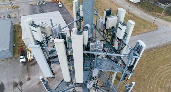
Structure Inspection

Utilizing our fleet of drones fitted with high-resolution sensors, we can scan the entire structure providing our clients with crystal-clear high-resolution imagery allowing their own in-house staff to review and

analyze the data first hand. We provide the entire data package, so that our clients can archive for historical records, safety audits, maintenance

audits, and insurance purposes. We also perform audits to verify proper equipment installation or all repairs have been completed. Geospatial Engineering Aerial LIDAR Topographic Mapping Land Surveying

Learn more

OUR CAPABILITIES

Differentiators

Geospatial Engineering

Geospatial Engineering

• LIDAR Services

• IT Specialists

• General Aviation Experience

• Thermal Imaging & Inspection Capabilities

• Variety of different data collection 

methods to suit needs

• FAA Waiver granted for Nighttime 

Operations

• Site/Project specific safety and 

operational procedures

• Top/Bottom mounted camera 

capabilities for inspections

• Non-invasive, easily implemented

• Full set of data collection options Geospatial Engineering Aerial LIDAR Topographic Mapping Land Surveying


Learn more

Geospatial Engineering

Geospatial Engineering

Geospatial Engineering

PAS specializes in aerial mapping and survey, 

utilizing Unmanned Aerial Vehicles (UAVs), 

commonly known as drones. Projects requiring 

ultra-high image resolution and survey-grade 

geo-positional accuracy are best captured 

using UAV technology. We provide a true end-

to-end solution, from flight planning, aerial 

imagery capture, advanced processing 

technics, and proprietary analytics enabling 

our clients to get the most value out of their 

data.


• Survey/Engineering Data collection

• Ground/Earthwork Survey data

• Contours/Elevation map data

• Interactive 3D model data

• 3D Surface map data

• 3D point clouds data

• 3D mesh models data

• DTM (Digital Terrian Map) data

• DSM (Digital Surface Map) data

• 2D Orthomosaic map data

• Land surveyor data

• Volumetric data (Volumetrics)

• Stockpile Measurements

• Cut and fill data

• Tree Surveys

  • • Corridor-Vertical Mapping Geospatial Engineering Aerial LIDAR Topographic Mapping Land Surveying

Learn more

Core Data

Geospatial Engineering

Core Data

DUNS: 076055523

CAGE: 8TJU8

SAM ID: YJYHHL5MBUH7


NAICS CODES:

115116 115210

115310 111421 

541715 213112 

213113 213114 

213115 237120 

213111 486110 

238910 541690 

541360 236220 

237310 237120 

237130 238910 

541330 541340 

541360 541370 

541990 541512 

531390 541922 

541490 512110 

236116 237990 

212321 238110 drone photography Photogrammetry Drone Mapping


Learn more

Our Services

Industries Served

Project Imaging Services

Project Imaging Services

• Government (Local/State/Federal)

• Oil and Gas

• Construction

• Infrastructure

• Agriculture

• Forestry

• Golf Course

• Resorts/Campground

• Real Estate

• Insurance

• Power and Utilities

• Emergency Management

• SAR Geospatial Engineering Aerial LIDAR Topographic Mapping Land Surveying


Project Imaging Services

Project Imaging Services

Project Imaging Services

• General Photography

• Aerial/Ground high-resolution Photography 

and Video production services Aerial/

Ground full 360° panoramic photos and 

video capture.

• Interior full 360° panoramic photos and 

video capture.

• Pre-construction\planning LIDAR data, 

aerial/ ground photographic imaging/

documentation of the proposed job site 

and surrounding areas. 

• Project progression documentation

• Exterior via UAV and ground data capture

• LIDAR (SLAM) Interior imaging and mapping 

services

• Time-Lapse Imaging Services

• Site Progression images and videography, 

including hyper-lapse images of your 

project from start to finish. Geospatial Engineering Aerial LIDAR Topographic Mapping Land Surveying Drone Mapping Photogrammetry 


Certification

Project Imaging Services

Certification

INDOT MBE

SBA DBE

State of Indiana MBE

City of Indianapolis MBE

Dun and Bradstreet

SBA HubZone Geospatial Engineering Aerial LIDAR Topographic Mapping Land Surveying

Our Certifications

Discount Photogrammetry 3D Lidar Imaging construction progress photography video

DBE & MBE CERTIFIED

  • FAA Part 107 Certification
  • Private Pilot
  • A+ Certification
  • Property Inspection Certification drone photography and video aerial Geospatial Engineering Aerial LIDAR Topographic Mapping Land Surveying Photogrammetry Drone Mapping

Drone Pre - Post Construction Services.

Check out this great video

Welcome


Hello!

My name is John Carter and I would like to take this opportunity to introduce you to our company and the services Precision Aerial Services, LLC provides. 

Precision Aerial Services, LLC is a Drone-based Aerial Imaging and data capturing company offering many services that are very beneficial to organizations li Geospatial Engineering Aerial LIDAR Topographic Mapping Land Surveying Drone LiDAR Discount Lidar drone photography Photogrammetry Drone Mapping

Find out more
  • HOME Drone Services
  • CLIENTS & PROJECTS
  • CONTACT US
  • Construction Services
  • Structure Drone Services
  • Welcome
  • Aerial Lidar Services

PRECISION AERIAL SERVICES, LLC

2633 Beech Drive, Evansville, IN 47714

812.550.5063

Copyright © 2021 PRECISION AERIAL SERVICES, LLC Indiana Construction Drone, Kentucky Construction Drone, Ohio Construction Drone LIDAR Specialists

All Rights Reserved.

This website uses cookies.

We use cookies to analyze website traffic and optimize your website experience. By accepting our use of cookies, your data will be aggregated with all other user data.

DeclineAccept